ArcGIS Explorer 9.2
Free
4

Latest version:
10.0.1700
See all
Sharing of information has become much more easier nowadays with the advent of the new technology, with new areas being explored on a daily basis. Information of geography, effectively being depicted by maps and drawings, has become much more easier nowadays, unleashing the power of imagination and interpretation of given data by a number of people across the globe.
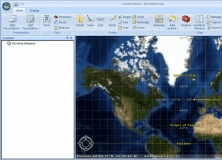
ArcGIS Explorer from the stable of ESRI is one such software, a freeware that can be used for sharing maps and interpretation of the same with others across the Internet in a simple and effective way. The software comes with inbuilt features such as imagery, street maps, historical maps, shaded relief, topographic maps and such other relevant features.
Using this software, one can easily customize the maps by adding layers and combining the same with the available local data regarding geographical features. Relevant data and maps from one’s personal collection in the respective servers can be effectively fused with services provided by ESRI such as ArcGIS Server, ArcIMS, Open Geospatial Consortium as well as ArcWeb Services
The software enables the performance of GIS analysis including modeling, proximity search and visibility. The software also has features to frame questions as well as deduce answers about the maps custom-built using the resources and data.
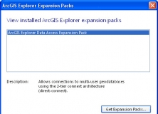
It expands the geodatabase functionality of the ArcGIS Explorer Desktop app.
It adds projections and geotransformations for use with ArcGIS Explorer Desktop.

It is a plug-in that provides interoperability between AutoCAD and ArcGIS.


Comments (1)