v10.0 [Mar 10, 2010]
New capabilities of ArcGIS Explorer Desktop include:
-GPS integration—A USB or Bluetooth NMEA GPS Receiver can be connected to ArcGIS Explorer Desktop to see real time location, enter waypoints and track location.
-Spatial selection—Use shapes to query features with spatial operators such as contains, intersects, or within.
- Image georeferencing—ArcGIS Explorer Desktop now includes georeferencing tools for non-georeferenced rasters.
- Support for adding geotagged photos
-Ability to geotag photos interactively
- Query by attribute for layer packages
- KML improvements
v9.3 [Aug 29, 2011]
New capabilities of ArcGIS Explorer Desktop (build 1700) include:
-GPS integration—A USB or Bluetooth NMEA GPS Receiver can be connected to ArcGIS Explorer Desktop to see real time location, enter waypoints and track location.
-Spatial selection—Use shapes to query features with spatial operators such as contains, intersects, or within.
-Image georeferencing—ArcGIS Explorer Desktop now includes georeferencing tools for non-georeferenced rasters.
-Support for adding geotagged photos
-Ability to geotag photos interactively
-Query by attribute for layer packages
-KML improvements
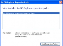
It expands the geodatabase functionality of the ArcGIS Explorer Desktop app.
It adds projections and geotransformations for use with ArcGIS Explorer Desktop.

It is a plug-in that provides interoperability between AutoCAD and ArcGIS.